by Pratiksha Baruah* and Rajendra Prasad Naik** 23 May 2020
ABSTRACT
Urbanization is a process that leads to the growth of cities, drastically changes the characteristics of previously natural areas, causing various environmental impacts. Guwahati is blessed with rivers, waterbodies and a number of hillocks. However, rapid, unplanned and organic urban growth in Guwahati has changed the land use pattern of the city. Uncontrolled development activities have therefore led to have done a lot of harm to the ecology and environment of the city. One of the wetlands in the city is Deepor Beel, Ramsar Wetland which is under threat due to the encroachment and unplanned urban development of the city. With a significant population growth, the city also faces floods and landslides due to several anthropogenic activities.
This paper attempts to examine how environment issues have been addressed in the planning of Guwahati Metropolitan Area (GMA) with reference to the Masterplan for Guwahati Metropolitan Area with perspective till 2025.
INTRODUCTION
The process of development has caused negative impacts on natural eco-systems of cities making them prone to various environmental hazards. Master Plan or Development Plan as an instrument to work out land and infrastructure requirements for various urban or rural uses, the purpose of a Master Plan is to promote growth and regulate present and future development of towns and cities that would result in harmonious and sustainable distribution of activities through allocation of land for various uses. Therefore, any plan prepared for the city needs to address the issues related to safeguarding the environment and provide a road map for up scaling the quality of environment. Accordingly, development plans prepared for any area should be holistic plans covering physical, economic, social, and environment aspects.
Integrating the environment in urban planning can help in efficient management of cities. There is a need of bringing a balance in a development process between conserving natural resources and at the same time supporting varying requirements of cities. Addressing the crucial challenges is the key concern for city planners and environment planning in environment planning of cities to manage productive lands for urban uses.
ENVIRONMENTAL PROFILE OF GUWAHATI
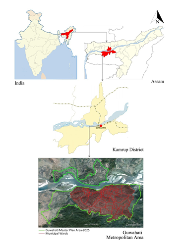
Guwahati, also known as Pragjyotishpura, the City of Eastern Light is located in the Kamrup District of Assam. Guwahati, situated along the Brahmaputra River and towards the south-eastern side of Kamrup district, is bounded by Nalbari district in the North, Darrang and Marigaon districts in the East, Goalpara & Barpeta districts in the West and Meghalaya State in the south. The city has a rich historical past that goes back to several thousands of years.
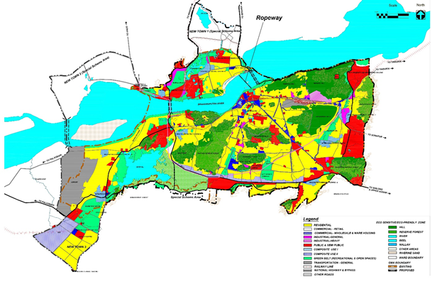
In 1974, the Guwahati Municipal Corporation was constituted with 34 wards. With a significant rise in population, the State Government prepared a Master Plan for Greater Guwahati in 1965 with a perspective of 20 years in order to deal with the rapid urbanization. In February 1987, the Modified Master Plan and Zoning Regulations with perspective till 2001 for the town were published entrusting the Guwahati Metropolitan Development Authority for implementation. However, the plan has been further revised to have a Comprehensive Master Plan (CMP) for Guwahati Metropolitan Area (GMA) with perspective till 2025 under the GMDA Act, 1985. The proposed GMA (Figure 1) within the Greater Guwahati Area has a total area of 328 square kilometers that includes 13 Planning Units and 3 units of three New Towns. The proposed masterplan is as shown in Figure 2.
The topography of Guwahati is significantly undulating that ranges from 49.5 meters to 55.5 meters above Mean Sea Level (MSL). The land is interspersed with a large number of hills. The central part of the city has small hillocks namely Sarania hill, Nabagrah hill, Nilanchal hill and Chunsali hill. The Buragosain Parbat in the East and the hills of Rani and Garbhanga in the south form the major hill formations of the city making a contiguous formation with the hills of Meghalaya. With a total of 18 hills in the city, the total reported area covered by hills in GMA is 68.81 square kilometers and the existence of forests in the city is largely confined to the hill areas. Barring the rocky outcrops, the hills are mostly covered with forests that varies from Sal forests, Mixed Moist Deciduous Forests, Evergreen Forest, Bamboo Brakes and Secondary Scrub Forests. The GMDA’s environment is characterized by reserved forest that accounts to a total forest area of 333.42 square kilometers.
The GMA is traversed by two major rivers namely the Brahmaputra River and the Bharalu River. The Brahmaputra river, the 9th largest river by discharge and 15th longest river in the world is a major natural feature of the State and has total length of 28.67 kilometers and a total area of 49 square kilometers in Guwahati. The Bharalu River rises as a small stream from the southern range of Khasi Hills in the state of Meghalaya and Guwahati gains momentum in width and depth while flowing through Guwahati and ultimately joins the river Brahmaputra. Due to siltation, the bed level of river Bharalu has considerably risen. The shores often create temporary wetlands in winter.
Guwahati is blessed with the wetland- Deepor Beel. ‘Beel’, in Assamese, means a wetland or a waterbody with diverse flora and fauna. Deepor Beel is a natural, permanent wetland, located towards the southwest of Guwahati, considered as an important riverine wetland in the Brahmaputra valley of Assam. Deepor Beel was declared as “Wetlands of International Importance” under the Ramsar Convention on wetlands, 1971 and was declared as Ramsar site in 2002. The wetland is the natural habitat to many species of birds, various aquatic life and vegetation.
There are other wetlands namely- Borsola Beel, Sarusola Beel, Narengi Beel and Silsako Beel, with rich flora and fauna and a self-sustaining ecosystem in the heart of the city.
The rivulets, Bharalu river and Basistha river are the natural drainage channels for Guwahati Metropolitan Area with their outfall in the Brahmaputra River and Deepor Beel respectively. Considering the topographical features in GMA, the whole region area is divided into 6 natural drainage basins that ultimately drains into the river Brahmaputra either directly or through various drainage channels and reservoirs. These are Silsako Basin, Bharalu Basin, Foreshore Basin, Deepor Basin, Kalmoni Basin, and North Guwahati Basin.
Source: Masterplan for Guwahati Metropolitan Area-2025
Environmental Challenges
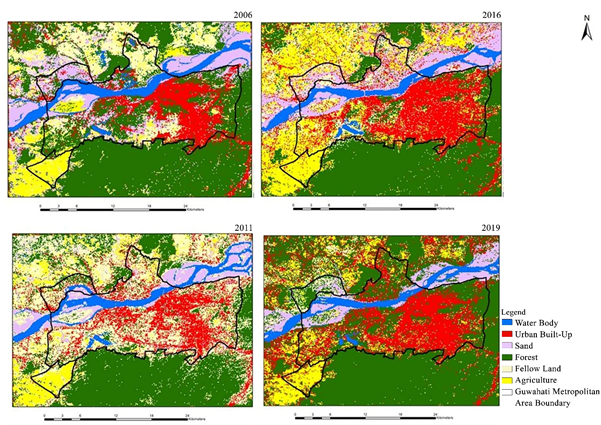
The urban growth in the city has been rapid, unplanned and organic. With increased urban sprawl, the urban built-up area has increased by 87.57% but with a significant decrease of Water body area and Forest area by 24.4% and 16.7% respectively. The change in landuse and landcover from 2006-2019 are as shown in Figure 3.
Population growth, migration and change in land use pattern at fast pace due to uncontrolled development activities have resulted into significant detoriation of the ecology and environment of the city-
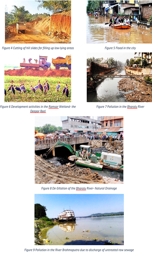
- The removal of vegetation cover in the forest area and exposed surface as a result of growing constructions on the hills in the city is identified in the master plan. The problem of soil erosion along with many environmental issues like water logging, flash flood, decrease in ground water table and dusty environment on sunny days are described as significant impacts in the Masterplan.
- Wetland degeneration is described as a noteworthy problem in Guwahati that is resulting into shrinking of Ramsar site- Dipar beel wetland (Figure 6) and other wetlands in the city by encroachment, natural siltation, earth filing and garbage dumping. Master plan further correlates the issues in wetlands to decrease in the water retention capacity, siltation in wetlands and drains, flash floods, water logging and depletion of the flora and fauna.
- There has been an increasing pollution in River Brahmaputra (Figure 9) and Bharalu River (Figure 7) due to discharge of untreated raw sewage directly into the river. The ground water pollution generally shows a moderate mineral content with slightly higher concentration of iron and the toxic elements. Wastewater from households, commercial establishments and various industries also ends up in the Bharalu River which gets discharged in the Brahmaputra river. River Brahmaputra has excessive bacterial pollution due to discharge of raw sewage and the presence of dissolved oxygen in the River Bharalu due to the presence of various oxygen demanding matter in flowing into the river.
- Anthropogenic activities like cutting of hill slides (Figure 4) for filling up low-lying areas, deforestation at a large scale are causing ecological issues like sheet-wash, high rate of soil erosion, bottlenecking drainage channels and urban flooding. Flooding events have become quite common in Guwahati in past few years (Figure 5). According to the city assessment report, backflow of the water from the River Brahmaputra, due to blockage in the drainage system through natural drainages causes floods frequently every monsoon probably because most of the drains fall on the upstream side of River Bharalu.
- Due to heavy siltation (Figure 8), the bed level of rivers has risen. The capacity of natural drainage to discharge storm water to main arteries and reservoirs have been reduced to a great extent.
Wastes and effluents from the Refinery that flows directly to the rivers has resulted in degradation of the water quality of the river and it has been reduced to a drain.
Efforts of Masterplan in addressing the Issues
There is a need to understand about how the master plan strategically plans to accommodate the subsequent increase in demand due to population increase in the city. Guwahati is the largest city in the Indian state of Assam and also the largest metropolis in the northeastern India. With a current population of 19.10 lakhs in the base year – 2005, it is expected to increase to 22.50 lakhs people in 2025 which implies that there is a significant demand to accommodate to their needs in the Guwahati Metropolitan Area.
The Master Plan envisages for development of the city through 2025 by making Guwahati one of the most admired state capitals of India as gateway of the north-east with a unique image of its own. Objectives of the Master Plan for Guwahati Metropolitan Area – 2025 towards managing the environment are conserving Guwahati’s major features in their pristine glory, creating a new image to the State capital and bringing in an alternative land development process with all new features to be adopted. The Masterplan have discussed all the major environment issues in detail and recommended appropriate strategies to overcome the issues. Separate Chapters have been dedicated for Environment Sensitive areas and Natural Drainage in Chapter- Environment and Natural Hazards and Chapter- Drainage, respectively. The Masterplan have attempted to preserve the Environment sensitive / Eco-sensitive areas (Figure 2) by appropriate zoning to protect the fragile areas.
The planning principles adopted in the Masterplan to protect the eco – sensitive areas through landuse are:
- The landuse plan has identified the vulnerable natural drainage basins for blockage and flooding and these areas have been discouraged for further encroachments. A new canal to take excess water may be built where Highest Flood Level (HFL) of the river is lower than the city level.
- All the hills and water bodies (rivers and wetlands) have been categorized as Eco-sensitive zone in the Masterplan which are to be conserved with no urban developments.
- In the proposed Masterplan, permissibility with regards to different land uses in the Eco-Sensitive Zone shall only include- bird sanctuary, botanical garden, existing villages, fish curing, flood control work, forest, golf course, existing monuments, municipal facility, nursery, horticulture and orchards.
- The vast and beautiful expanse of the river Brahmaputra is conserved by the proposed River front development. The Masterplan also marked the River Development Zone in the existing area along the river as well as in the areas for new developments.
- The landuse plan proposes the area of Deepor Beel as under recreational zone for the city.
- On the basis of the city structure as envisaged for the GMA, the proposed land use pattern for planning unit delineates 26% for Eco-Sensitive/ Eco-Friendly Zone and 11% for Green belt that includes both Recreation & Open Space.
- A new city structure for GMA is envisaged for the integrated hierarchical development of the city and development of City Image through the creation of landmarks and by developing a hierarchical city structure into 3 tiers and creation of 3 new towns.
- In the areas for new developments, as per CRZ III, a 200-meter-wide green belt has been marked as recreational green.
Development Control Regulations considered for conservation of the Environment-
- As per Development Regulation, the site will not be considered for development: The land in the proposed Guwahati Metropolitan Area has been categorized into nine Land Use Zones: i) Residential Zone; ii) Commercial Zone; iii) Industrial Zone; iv) Public/Semi-Public (P & SP) Facilities Zone; v) Transport and Communication Zone; vi) Green Belt Zone (Recreational and Open Space); vii) Eco-Sensitive / Eco-Friendly Zone; viii) Composite Use Zone – I (includes Residential, Commercial and P & SP); ix) Composite Use Zone – II (includes Residential, Commercial, P & SP and existing Industrial).
- All existing non-nuisance, non-polluting uses may be allowed to continue/discontinue after an application for special permission to the Authority in the eco-sensitive zones and eco-friendly zones.
- The plan proposes that in recreation and eco-sensitive zone, parks, parking, circulation and utilities would be permissible only with special permission from the Authority.
- The Industrial Sub-division provides for 10 % of the area to be reserved as recreational and green belt. Also, the effluent from water polluting industries shall be treated at common treatment plant before it is discharged into regular sewers.
- In the areas for new developments, as per CRZ III, a 200 m wide green belt has been marked as recreational green. Area for the same is indicated in the land use plan.
The map for the proposed Eco-sensitive areas in GMA-2025 is shown.
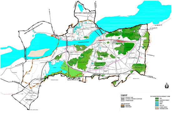
Source: Masterplan for Guwahati Metropolitan Area-2025
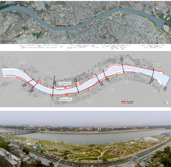
Case Study: The Sabarmati Riverfront
The Sabarmati Riverfront Project (Figure 11) by the Ahmedabad Municipal Corporation is an example of changing the character of a city from the centre outwards in an environmentally and socially responsible way. The riverfront project transforms the private river edge into a public asset, redefining the city’s relationship with its river. Various developments are planned along the reclaimed land ranging from parklands to commercial development.
The Riverfront project presents a great opportunity to create a public edge to the river on the eastern and western sides of Ahmedabad. By channeling the river to a constant width of 263m, riverbed land has been reclaimed to create 11.25 kms of public riverfront on both the banks. The total land reclamation is 204.91 hectares. Key features of the project include- river promenade, parks & plazas, streets on both side of the river and amenities like sports facilities, riverfront market, exhibition centre, integrated outdoor vending areas, etc.
![]()
Policies/Strategies proposed for the improvement of Environment in the GMA
The policies and strategies for the management of the environment in GMA as proposed are-
- The masterplan identifies the need to restrict any further encroachments and prohibiting any cutting of trees to conserve the sanctity of the forest areas. The masterplan also proposes massive afforestation programmes that will be undertaken to increase the green cover in the city.
- Preparation of landscape plans, and large-scale plantation is also envisaged in the plan.
- For the sustained wetlands in GMA, the plan has recommended to prohibit earth filling in the wet and low-lying areas and dumping of wastes in and around the wetlands. The plan also suggests the area of Deepor Beel to be used as tourist attraction.
- To overcome sewage entering into the waterbodies, the remedy as recommended by the plan is to provide sewage treatment and solid waste management for all residential and other urban areas.
- To overcome inadequate and insufficient drains, the plan recommends immediate arrangements of construction of storm drains for efficient and quick removal of storm water from the populated areas of the city.
Conclusion and Recommendation
There are no special regulations incorporated in Development Regulations to protect the environmentally fragile areas. The Urban Development Regulations (Government of Assam, 2014) prohibits erection of any buildings on a site liable to flood or on a slope forming an angle of more than 45 degree with the horizontal or on soil unsuitable for percolation unless it is proved by the owner to the satisfaction of the Authority that erection of such a building shall not be dangerous or injurious to health or involve danger from flooding or erosion or cause undue expenditure of public fund in the provision of roads, sewage, sanitation, water supply or other public services. Also, it mandates restriction of constructing any building with its lowest flat or floor 0.3 m higher than the highest recorded flood level (as certified by the local authority) and per permission of multistoried building in – (1) areas falling on or abutting wetlands; (2) areas falling on or abutting natural drainage channels; (3) sites on hills and foothills requiring excavation that is likely to cause soil erosion, landslide or instability of hill slope; and sites below overhanging embedded rocks; (4) Government land in the hills and in the water bodies like beels; and (5) notified forest land falling within the Master Plan areas.
The Master Plan needs to demarcate eco-sensitive areas in the city as low/no built up areas according to given rules and norms according to Urban Development Regulations and Urban Regional Development Plans Formulation and Implementation (URDPFI) Guidelines. Also, the encroachments in the waterbodies should have been recognized in the Masterplan. Having identified the drainage issues by the masterplan, the extent to which the conservation area extends in the city is not prescribed. It is necessary to carry out studies on the natural drainages that can help revive the effected ecosystems.
There is a need to integrate the Guwahati Masterplan with the Brahmaputra river basin to develop a comprehensive and integrated approach to the development. The River Development Zone has been marked in the existing area along the river. In the areas for new developments, as per CRZ III, a 200 meters wide green belt has been marked as recreational green. However, only a 6 km long Riverfront stretches between Rajbhawan (Kharghuli Hill) to famous Kamakhaya Temple (Nilachal Hill) while the riverbed land extends to approx. 21 kms in the southern bank and approx. 11 kms in the northern bank of the river Brahmaputra. During formulation of a basin master plan, it is crucial to have an appraisal of available land resources in the basin and their limitations and also discuss the planned growth of developed land areas and proposals for required development.
Creating a public riverfront on both the banks covering the entire length of the river passing through the GMDA area would be effective in management of the frequent floods.
Any plan prepared for the city shall address the issues related to safeguarding the environment and landuse map for improving the quality of environment. Since, urbanization will predominantly result in a physical growth of the city with noteworthy implications to the ecology and environment, mainstreaming environmental priorities into development plans through city development strategies shall work to reconcile urban growth with management of natural resources.
About the Authors
The authors have completed Masters in Planning with specialization in Environmental Planning and Management, from School of Planning and Architecture, Vijayawada (SPAV), Andhra Pradesh. Ms. Pratiksha Baruah is currently working with IPE Global for Shillong Smart City as an Urban Planner and Mr. Rajendra Prasad Naik is working as a Ward Planning and Regulation Secretary at Hindupur, Andhra Pradesh.