August 21, 2019 By Andy Heil

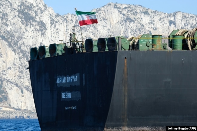
The supertanker formerly known as Grace 1 is steaming eastward in the Mediterranean Sea after six weeks in Gibraltar detention, reportedly still carrying more than 2 million barrels of potentially embargo-busting Iranian crude oil.
Iran insists the oil isn’t and never was destined for Syria, which is under U.S. and EU embargo.
But U.S. and European authorities appear wary, and U.S. officials who lost a bid to keep the Grace 1 in detention over alleged ties to Iran’s Islamic Revolutionary Guards Corps (IRGC) are warning ports against assisting the tanker, now renamed Adrian Darya 1.
So a high-stakes shell game involving what’s known as a very large crude carrier (VLCC) has moved to the 2.5 million-square-kilometer Mediterranean Sea.
The Adrian Darya 1’s movements are being closely tracked.
But experts have warned in the past of Iranian efforts to hide shipping activities to evade notice, including stepping up those tactics ahead of the reimposition last year of unilateral U.S. sanctions.
And they say that following the precise movements of even a massive tanker like the Adrian Darya 1 is more difficult than people might think.
“If you don’t want the world to know where your ship is, you can very easily hide it,” says Adrian Economakis, chief operating officer of VesselsValue, trackers of commercial and other ships’ movements and their cargoes. “That’s the challenge of the high seas.”
His and other companies follow tens of thousands of vessels around the world in real time.
The system is highly reliant on radio transmissions via what’s known as the Automatic Identification System (AIS) to a global patchwork of land-based stations and — especially at sea — low-orbiting satellites.
AIS began as a way to avoid collisions and groundings in shallow waters, trackers say, and wasn’t designed to track vessels globally. It has since been adapted into what Economakis calls a “creative solution” to track the world’s 50,000-plus merchant fleet and thousands of other vessels.
“The industry and technology players like us have developed a way of doing it, but…it’s not in any way a foolproof way of tracking the vessels,” Economakis says.
There are said to be new technologies under development, but none that can reliably track vessels.
“AIS is the best, easily accessible, way to track ships globally,” says Georgios Hatzimanolis, a media strategist at Marine Traffic, one of the world’s largest coastal-reception networks. “Satellite tracking is viable, but the shape-recognition technology isn’t matured and in place yet, and the satellite network for such a system [excluding, potentially, government agencies] isn’t active.”
Grace 1’s Case
Since its release last week, the Adrian Darya 1’s Iranian operator charted a course on August 16 for Kalamata, a southern Greek port known more for olive oil than crude.
The National, a United Arab Emirates-based news website, noted that Kalamata “has no oil infrastructure or facilities to handle a [VLCC] such as Grace 1.” And there was speculation that it was looking to offload 1 million barrels of crude.
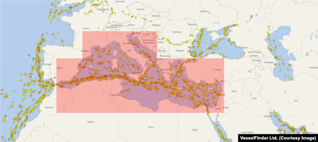
Two days into its current Mediterranean journey, you could plainly see Adrian Darya 1’s position on the website of VesselFinder, another ship tracker.
Under the UN Convention on the Law of the Sea, vessels of at least 300 deadweight tonnage — as is the Adrian Darya 1 — are required to have their AIS transponders on in international waters to regularly transmit their location, registration, speed, course, and other details.
But interruptions of the signals are routine due to onboard equipment failures — real or imagined — or “black spots” due to weak signals or obstructions, heavy radio traffic, or even local military restrictions.
And ships can “go dark” with little more than the flip of a switch of the transponder, with no direct penalties for noncompliance except possible insurance or liability problems.
Bodies like the UN’s International Maritime Organization (IMO) are constantly trying to discourage crews from turning AIS transponders off.
Iranian and Chinese vessels have been accused for years of switching off AIS when transferring and transporting Iranian crude oil, a major source of foreign income for a government that has spent decades under U.S. and UN sanctions.
In the months before the reimposition of U.S. sanctions in November 2018, vessel watchers like TankerTrackers.com were warning that “Iranian tankers are going to great extremes to hide their activities in the [Persian] Gulf waters.”
“A lot of the vessels remain offline, but we have learned a great deal now about their patterns and movements,” TankerTrackers.com said in September.
This summer, as it navigated from Iranian offshore waters and around Africa, reports claimed the authorities already suspected the Grace 1, now “loaded to capacity,” had used the tactic to avoid detection as it took on crude oil.
Based on the past observations of vessel watchers, here are six ways a tanker like the Adrian Darya 1 could again slip out of sight.
‘Going Dark’
Its crew could simply shut down its AIS transmissions to “go dark” at virtually any point on its journey, ostensibly to Kalamata, citing, for instance, a faulty antenna.
The ship would remain visible to radar, so radar tracking and other ships in the vicinity would still see it.
In the summer of 2018, TankerTrackers.com, a self-styled “vigilant and impartial watchdog” to ensure that governments and companies “stay honest,” followed a Turkish oil tanker after it left a Russian Black Sea oil terminal and entered the Mediterranean Sea.
“Once she entered the high seas, the vessel disappeared off the map,” it said in an October report on “clandestine oil transfers,” adding, “This was an intentional effort to go dark.”
Satellite sleuthing and trajectories once the same ship came back online 10 days later suggested to TankerTrackers.com that it had stopped at Ashkelon, an Israeli port that can handle big tankers, possibly to unload and load more crude oil, and was now bound for Spain.
“If a ship is going from an embargo country to another country and they want to hide their tracks — they don’t want the world to know where they went — the easiest thing is for them to turn their AIS off, even though it’s not according to the law,” says Mihail Mitev, manager of commercial sales for VesselFinder.
Trackers say there is almost no way outsiders can be certain why a ship’s transponder was turned off.
Ships In The Night
Another method that utilizes going dark aims to disguise the origin or destination of a ship’s cargo.
And it can be employed by either side in the exchange, while stationary or under way.
Ship-to-ship transfers of cargo are common but also uncommonly tough to decipher in any detailed way if one of the vessels is unidentified — even despite telltale signs that hint at what’s happening.
“I mean, if you see a ship sailing en route to Kalamata, for example, and it coincidentally stops at a place — with other ships or with no ships — for a long time, [and] it makes some strange changes in its course or direction, then we can certainly deduce that something strange happened at that time,” Mitev says.
Experts say ship-to-ship exchanges are particularly effective for tankers, whose liquid cargo is easy to transfer.
Such encounters are thought to be one of the main ways that Tehran has continued to sell large amounts of oil while under international and, now, U.S. sanctions.
Phantom Coordinates
Trackers report encountering alternatives to going dark in which ships’ AIS data is somehow falsified.
Put simply, a ship transmits data that is received by a land-based station that in turn passes along that information to a station owner or a tracker. But what if, somewhere along the way after it’s sent, that data is manipulated to misrepresent the ship’s location?
“There’s such software or devices that move the coordinates of the real position of the ship,” Mitev says. “They automatically substitute the real coordinates of the ship with other coordinates — moving its position several degrees east or west, which will certainly move its position a few [nautical] miles or a few hundred miles to another position where it’s not actually at right now.”
Land-based devices are supposed to gather AIS signals at least every minute or so, while gathering signals via satellite — the only option in some cases — is far less frequent.
So such problems can be hard to spot initially, especially on the high seas, but trackers can drill down a bit once they know what they’re after.
“If you want to be 100 percent sure what [a ship] did in the past, and whether that data’s accurate, you get historical data for that ship,” Mitev says. “You can easily evaluate what happens with that ship — even if there are a few incorrectly transmitted positions, it would still be easy for you if you see the whole picture of her movements to evaluate what she did.”
A Friend Indeed
So long as it avoids ports along the way or only stops at the ports or offshore facilities of friendly states, the Adrian Darya 1 could remain off AIS indefinitely and lose itself in the Mediterranean’s heavy traffic.
It was sharing the Mediterranean with roughly 900 other tanker ships and 2,000 cargo ships on August 20, according to VesselFinder.
“The time when you get found out is when you’re coming into port,” VesselsValue’s Economakis says. “So as long as you’re going into ports where that port is not necessarily going to report you to the authority that is looking for the ship, it is very easy to hide.”
One tracking-company executive cites the unlikelihood that officials would bother to report irregularities under certain circumstances, including to the authorities of an unfriendly country or even a friendly one if it reflected badly on the country that spotted it.
Tailgating
It elicited chuckles from at least one tracking-company executive, but cargo ships have been known to go dark and then follow closely behind another that’s transmitting an AIS signal, in apparent hopes of avoiding detection.
One such effort was spotted last year by TankerTrackers.com, which declined to comment for this article. It described the twin travelers as “Iranian tankers” alongside a satellite photo it said was from the Persian Gulf.
A New Identity
Tankers have also been known to go dark only to quickly reappear under new identities and continue to new destinations.
In January 2018, trackers watched a tanker depart from a Turkish oil terminal before it disappeared from MarineTraffic’s map. A similar-sized tanker showing the same registration number and along a similar trajectory, but with a different name, popped up and continued to the Israeli port of Ashkelon.
“Guys, you’re gonna have to try harder than that,” TankerTrackers.com tweeted at the time.
A few weeks later, a tanker carrying Kurdish crude oil appeared to repeat the maneuver.
“OOPS, THEY DID IT AGAIN!” was TankerTrackers.com’s reaction.
- Andy Heil Andy Heil is a senior correspondent in RFE/RL’s Central Newsroom in Prague.HeilA@rferl.org