

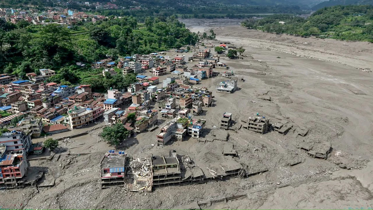
The catastrophic flash flood that swept through Nepal's Rasuwa district on August 26 was not merely an isolated natural disaster. It was another warning from the Hindu Kush Himalayan region, often called the "Third Pole," where climate change, unstable glaciers, fragile mountain geology, expanding infrastructure, and inadequate cross-border cooperation are creating increasingly dangerous conditions.
As rescue operations continued, Nepalese authorities reported at least 95 deaths in Nepal, while hundreds of residents, workers and foreign travelers remained unaccounted for. Because communications and roads were disrupted, the figures remained provisional. The disaster also affected neighboring Gyirong County in Tibet, where deaths and disappearances were reported. Associated Press
The flood devastated villages, roads, bridges and hydropower facilities along the river system. Hundreds of people were rescued, many by helicopter, while communities farther downstream were warned to leave vulnerable riverbanks.
A Glacier-Related Disaster
Initial assessments indicated that the flood originated near the Nepal-China border after an ice-and-rock avalanche entered or obstructed the Lhende Khola river system. The resulting accumulation and sudden release of water, ice, sediment and debris produced a destructive surge downstream. Authorities also warned that additional blockages could create the danger of a second flood.
Determining the exact sequence of events will take a scientific analysis. "It wouldn't be prudent to call it a glacial lake outburst flood, or GLOF, until we see satellite imagery and ground assessment to see what happened," he added. But a glacial surge triggered by an avalanche is part of a growing group of threats in high mountains, fueled by shrinking glaciers, melting permafrost, and unstable slopes.
Retreating glaciers may leave growing lakes dammed by unstable ice and loose rock. Landslides, avalanches, earthquakes, or heavy rainfall can trigger the collapse of such natural dams. Released water may carry sediment and boulders that sweep downstream as a debris flow through the river or lake channel that gave it birth, devastating towns and infrastructure within minutes.
Another transboundary flood occurred in Rasuwa in July 2025 that killed dozens of people. Afterward, scientists determined that the drainage of a supraglacial lake in Tibet caused the flood. The flood wiped out the Nepal-China Friendship Bridge and damaged large areas near the Rasuwagadhi border crossing.
The recurrence of a major disaster in roughly the same border region shows that Nepal faces a continuing structural danger rather than a series of unrelated accidents.
The "Third Pole" Is Losing Ice
The Hindu Kush Himalayan region contains one of the world's greatest concentrations of snow and ice outside the polar areas. Its rivers support approximately 240 million people in the mountains and another 1.65 billion downstream.
Research from the International Center for Integrated Mountain Development, or ICIMOD, shows that Himalayan glaciers are disappearing at an unprecedented rate. Under current emissions trajectories, glaciers in the region could lose as much as 80 percent of their present volume by the end of the century. Floods and landslides are expected to increase over the coming decades, even as long-term water availability becomes more uncertain.
This paradox lies at the heart of the crisis. Rapid melting increases runoff and expands glacial lakes. This increases the risk of devastating floods in the short term. In the long term, glacier retreat means that they will be less able to release water during dry periods to moderate river flows. Societies downstream could therefore experience both devastating floods and increased water scarcity.
In 2026, ICIMOD warned that glaciers in the Hindu Kush Himalaya had thinned by up to 27 meters since 1975. Observations are still patchy, though. Just a fraction of the region's glaciers is monitored regularly.
Infrastructure in an Unstable Landscape
Hydropower is essential to Nepal's economy and to regional efforts to reduce dependence on fossil fuels. Yet dams, roads, bridges and border facilities are being constructed in some of the most geologically unstable terrain on earth. An infrastructure project designed around historical flood patterns may be dangerously inadequate as glaciers, rainfall, and mountain slopes change rapidly.
Hydropower plants can also fall victim to glacial floods instead of causing them. Reservoirs and diversion structures can be buried by sediment, debris, and sudden releases. Roads built along steep rivers can focus development exactly where future floods will occur.
China's massive hydropower scheme on the lower reaches of the Yarlung Tsangpo shows how regional tensions fit into the bigger picture. This is not part of the river system that produced the Rasuwa flood and should not be offered up as another cause. Construction started on the five-station cascade in 20 25 at an estimated cost of 1.2 trillion yuan. The facility will generate some 300 billion kilowatt-hours per year, about three times the annual generation of the Three Gorges.
Known as the Brahmaputra once it crosses into India, the Yarlung Tsangpo empties into Bangladesh. Concerns have been raised about seismic activity, ecological changes, sedimentation rates, and sharing real-time hydrological information. China has stated the project will not impact downstream countries. Words will not substitute for transparency, independent assessment and genuine dialogue.
A Dangerous Governance Gap
China and India, or China, India, and Bangladesh, have never signed an enforceable, basin-wide water-sharing treaty. Two governments have negotiated limited hydrological data-sharing mechanisms for the flood season. But these agreements fall short of an enforceable treaty with inspections, consultations, and third-party dispute-resolution mechanisms.
Weak flood-season data-sharing agreements similarly hamstring cooperation along China-Nepal transboundary rivers. Nepal cannot comprehensively monitor every glacial lake, avalanche hotspot, or river-blocking landslide forming in the build-up zone inside Tibet. Once a destructive flood wave reaches the border, downstream communities may have only minutes to react.
Regional governments need real-time satellite and river monitoring networks, automatic early-warning stations, open emergency communication channels, and standardized evacuation procedures. Hydropower and transport infrastructure development must rigorously assess multi-hazards, including earthquakes, landslides, glacial floods, and potential cascading infrastructure failures, adjusted for climate change.
Investigations into the Rasuwa disaster should not apportion blame before the facts are known. Equally, lack of scientific certainty should not be allowed to become a reason for paralysis. If not this time, then next time. Whatever the proximate cause earthquake, avalanche, river blockage, or some combination of factors the broader risk is now clear.
Asia’s mountain glaciers and glacial systems are changing faster than governments are adapting to the growing risks downstream communities face. Unless secrecy and fragmented national responses give way to shared scientific data, effective early-warning systems, and coordinated cross-border action, disasters such as the one in Rasuwa will no longer be regarded as rare anomalies in an otherwise predictable Himalayan landscape. They risk becoming increasingly frequent features of a rapidly warming region.

0 Comments
LEAVE A COMMENT
Your email address will not be published