By Athar Parvaiz 1 September 2023
Sadiq Dar, 68, is surprised how the heavy siltation of Wular Lake has turned many of its areas into land masses. “When we were growing up, we would only see water in this lake. Now, we see cattle grazing in it while a large portion is also being used by children for playing cricket,” he tells IPS.
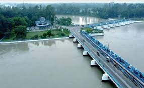
Overlooked by magnificent mountains, Wular Lake is one of the largest freshwater lakes in Asia and the largest flood basin of Kashmir in Bandipora district, some 34 km north of Srinagar, the summer capital of Indian Administered Kashmir.
An international Ramsar site under the Ramsar convention, this beautiful lake has served the people of Kashmir for centuries earning praises from all, including its poets.
“How long will they remain hidden from the world… the unique gems that Wular Lake holds in its depth,” 20th century Urdu poet Sir Muhammed Iqbal once wrote about Wular Lake’s depth and water expanse.
Almost a century after Iqbal’s inquisitiveness, the depths of Wular have become heavily silted, its size reduced, and its pristine waters suffer from heavy pollution. This large Himalayan water body and Dal Lake in Srinagar play a key role in flood management, water security, and livelihood generation in the region.
But a NASA report recently revealed that both these lakes—Dal Lake and Wular Lake—have witnessed a large reduction in size due to land conversions, urbanization, and deforestation in recent decades. This not only poses a threat of repeated flooding in Kashmir but will negatively influence livelihood generation and the availability of water for the communities.
“The conversion of forests to paved urban areas is a major driver of the change in water quality. Land conversion has delivered heavy sediment and nutrient loads into the lake, and untreated sewage from urban areas has also contributed,” says the NASA report.
“Some of the bright green areas on the eastern side of Wular Lake used to be open water. Nutrient-rich sediment and aquatic vegetation have filled in parts of the lake and contributed to its shrinking in recent decades,” the report further says and adds: “In a 2022 study, researchers in India—using data from the Indian Space Research Organization’s (ISRO) LISS-IV instrument—found that Wular Lake’s open water area had shrunk in size by about one-quarter between 2008 and 2019.”
In a detailed study of the lake, Wetlands International, a Netherlands-based not-for-profit that works to sustain and restore wetlands globally, had also revealed earlier that there was a 45 percent reduction in the lake area mainly because parts of the lake were converted for agriculture and willow tree plantations.
Wular Lake is crucial for saving Kashmir from floods. In recent years, the region has witnessed repeated flood-like situations following the devastating 2014 flooding. The recent IPPCC reports have predicted that there will be an increase in floods and other extreme weather events across South Asia in the coming years as the climate crisis deepens.
The Dal Lake, says the NASA report, has suffered a similar fate in response to land cover change. Researchers in Srinagar found that land conversion to urban development in the basin had worsened the lake’s water quality and contributed to its reduced size, the report says. They found that between 1980 and 2018, the lake shrunk in area by 25 percent, it added.
The marshy and water body area of Dal Lake, a major tourist attraction in Srinagar, has shrunk from 2,547 hectares in 1971 to 1,620 hectares in 2008, another study titled Impact of Urban Land Transformation on Water Bodies found earlier.
How to Stop the Lakes From Shrinking?
Wular Lake and Dal Lake are crucial for the region’s flood management and livelihood generation. Besides acting as a flood absorption basin for Kashmir during high flows in the region’s major river, Jhelum, Wular, and Dal Lake provide livelihood support to over 100,000 families dependent on tourism and fishing, said Samiullah Bhat, senior Assistant Professor at Kashmir University’s Environment and Science department.
To stop further shrinkage of Wular and Dal Lakes, Bhat said that soil erosion in the catchment area of these water bodies, which is resulting in these lakes becoming silted up, must be stopped. “It is because of the massive soil erosion that parts of water bodies are turning into landmasses,” Bhat told IPS.
Regarding encroachments in these lakes, Bhat said that geofencing is one way to mark the boundaries of these lakes, followed by close monitoring. “It has been done recently in the case of Wular Lake, and the same can be done for Dal Lake as well,” Bhat said.
“It is a matter of proper governance, management, and effective enforcement of laws for the protection of environmental assets,” he further said, adding that land ownership records and revenue records are also not that transparent, which also need to be addressed for protecting these lakes from further damage.
According to a study, Dal Lake represents a case of a threatened ecosystem in dire need of management, with land use changes, erosion, enhanced nutrient enrichment, and rising human population in its catchment as the major threats to its existence.
“Regulation of a proper land use plan in the Dal Lake catchment is vital for preventing the further nutrient enrichment and sedimentation of the lake waters,” the study says.
Aijaz Rasool, an engineer who has worked on these water bodies previously, said that all the areas of Dal Lake and Wular Lake need to be prioritized for complete conservation work. “For years, I have observed that only those areas of the lakes get attention which are visited by tourists, the other sides get least or no attention and keep deteriorating and encroaching. For example, the northwestern parts of Dal Lake and Wular,” Rasool said and added that once all the areas of these lakes receive equal conservational treatment, conserving them will get easier.
By Athar Parvaiz – IPS UN Bureau / Globetrotter

