By GreatGameIndia -November 7, 2019
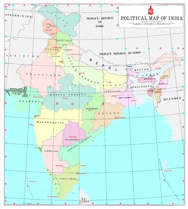
The Government of India released a new political map of India after two new Union Territories – Jammu & Kashmir and Ladakh came into existence on October 31, 2019. Nepal has rejected this new Indian map over Kalapani territory disputed since the treaty signed between British East India Company and Nepal. The Foreign Ministry said that Kalapani is a part of its territory and that it is committed to protect Nepal’s territorial integrity.

Nepal on Wednesday formally protested over the inclusion of the region of Kalapani in the new political map of India. A press release by the Ministry of Foreign Affairs of Nepal said Kathmandu is committed to protect Nepal’s territorial integrity.
“Nepal is clear that Kalapani is a part of Nepali territory. We are committed to protect the international boundaries of Nepal and for that we have diplomatic dialogue with friendly nations,” Nepali foreign ministry said.
Heres the New Political Map of India specifying the newly marked boundaries of the Union Territories of Jammu and #Kashmir and #Ladakh.
1086:39 AM – Nov 2, 2019Twitter Ads info and privacy47 people are talking about this
The latest political map of India reiterated the Indian claims on the region that Nepal says belongs to its westernmost part. India claims the historic region as part of the state of Uttarakhand.
Leaders from both ruling and opposition parties expressed reservations after the publication of new Indian political map.

‘Nepal govt is clear that Kalapani area belongs to us’
Ministry of Foreign Affairs issues statement following controversy after newly unveiled #IndianMap included the the area inside Indian territory #Kapalani
786:54 AM – Nov 6, 2019Twitter Ads info and privacy58 people are talking about this
Speaking to journalists in Dang, Chairperson of the ruling Nepal Communist Party (NCP) Pushpa Kamal Dahal said if a unilateral decision was taken on Kalapani the government and parties should take the issue seriously.
Nepali Congress lawmaker Dila Sangroula said Nepali people would never accept an Indian political map depicting Kalapani, Lipulekh and Limpiadhura as Indian territories. “Kalapani, Lipulekh and Limpiadhura belong to Nepal,” she said in a Twitter post.

Dr Dila Sangroula@dilasangroula
विवादित भारतीय नक्सा प्रकरण – संसदको विशेष अधिवेशन बोलाएर छलफल गर्न कांग्रेसको माग http://lokaantar.com/samachar/91212 विवादित भारतीय नक्सा प्रकरण – संसदको विशेष अधिवेशन बोलाएर छलफल गर्न कांग्रेसको मागकाठमाडौँ – भारतले आफ्नो राजनीतिक नक्सामा नेपालको भूभाग समेटेको भन्दै प्रमुख प्रतिपक्षी दल नेपाली कांग्रेसका नेताहरू आक्रोशित भएका छन् ।कांग्रेसका प्रवक्ता विश्वप्रकाश शर्माले भारतको कदमको विरोध गरे…lokaantar.com149:14 AM – Nov 6, 2019Twitter Ads info and privacySee Dr Dila Sangroula’s other Tweets
Former foreign secretary Madhu Raman Acharya said there was enough evidence to suggest that Nepal’s westernmost boundary with India went beyond Lipulekh and Kalapani. “Nepal should ask India to withdraw any map that alters the status quo unilaterally until the disputed boundary is resolved bilaterally,” he said in a Twitter post. Both Nepal and India claim Kalapani as their territory. The region has been occupied by Indian security forces since 1962, and the region has been disputed ever since.

Madhu Raman Acharya@MadhuRamanACH
There is enough evidence that Nepal’s westernmost boundary with India goes beyond the areas of Lipulekh and Kalapani inside Nepal’s territory.
Nepal should ask India to withdraw any map that alters the status quo unilaterally until the disputed boundary is resolved bilaterally.1984:19 AM – Nov 6, 2019Twitter Ads info and privacy70 people are talking about this
Also, during Indian Prime Minister Narendra Modi’s visit to China in 2015, the two countries had agreed to open a trading post in Lipulekh, another disputed area near Kalapani. Modi and Xi had made a joint statement stating that Lipulekh was a bilateral trade route between the two countries. Nepal has been opposing the statement saying it was against the provisions of the 1816 Sugauli Treaty signed between Nepal and India.
Minister of Foreign Affairs Pradeep Kumar Gyawali had said in February that India and China could not discuss Lipulekh in Nepal’s absence. Speaking in a meeting of the International Relations Committee of House of Representatives, Gyawali had said Nepal would not sign on the Nepal-India border strip map unless Kalapani and Susta disputes were resolved.
Kalapani Territory
Kalapani is a territory disputed between India and Nepal, however administrated as part of Pithoragarh district in the Uttarakhand state of India. It is situated on the Kailash Manasarovar route, at an altitude of 3600 meters. It is said that the Great Sage Vyasa meditated at this place, giving the region its name – Vyas Valley. A pool by the temple of the Goddess Kali is considered to by some to be the source of the Kali River.

A verdant valley covered with Pine, Bhojpatra and Juniper trees, it offers stunning views of some of the lesser known peaks like Om Parvat in the Central Himalayas. Lipulekh Pass leading into Tibet is 17 kilometers north from Kalapani.
Although claimed by Nepal as part of Darchula District, Kalapani is controlled by India’s Indo-Tibetan Border Police since the 1962 border war with China. Nepal claims that the river to the west of Kalapani is main Kali, hence it belongs to Nepal. But India claims that ridgeline to the east of Kalapani is the border, hence the Kalapani area belongs to India.
Treaty of Sugauli
The Kalapani area borders the Nepalese province of Sudurpashchim Pradesh and the Indian state of Uttarakhand. The Treaty of Sugauli signed by Nepal and British East India Company in 1816 locates the Kali River as Nepal’s western boundary with India and makes no mention of ridgelines. Subsequent maps drawn by British surveyors show the source of the boundary river at different places.